Those interested in aerial photographs, satellite images, or maps as ways to conceptualize the world, will find this site interesting, entertaining, and educational. The US Dept. of Interior offers a National Atlas of the United States, an interactive resource that allows users to view part or all of the US and overlay layers of information including natural features, political boundaries, federal...
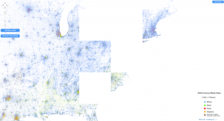
Created by Dustin Cable at the University of Virginia's Weldon Cooper Center for Public Service, the Racial Dot Map provides "an accessible visualization of geographic distribution, population density, and racial diversity of the American people in every neighborhood in the entire country." As such, it displays over 308 million dots, color-coded by race, for each person residing in the United...
The United States Census Bureau publishes hundreds of reports and statistical updates each year that are quite popular with public policy makers, researchers, and interested members of the public. This recent interactive map draws on data from the County Business Patterns program to highlight annual statistics for businesses with paid employees within the U.S. and Puerto Rico. The business...