The National Park Service has done a smash up job of creating thoughtful and compelling historical travel itineraries and this one is no exception. This particular tour takes visitors through the world of the American Latino experience via key sites around the country. First-time visitors will want to look through the Essays section to get a better context for all of these destinations. The essays...
American Memory, the Library of Congress' "gateway to rich primary source materials relating to the history and culture of the United States," offers this gem of a site on exploration and land use in the US. These historic and recent maps will be of great interest to ecologists, as they show "changes in the landscape, including natural and man-made features, recreational and wilderness areas,...
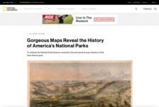
In 2016, the Pusey Library at Harvard University created an exhibit of historic maps in honor of the centennial of the National Park Service. The exhibit, entitled "The Land Remains: A Century of Conservation in America's National Parks" featured maps from the impressive Harvard Map Collection (which features approximately 400,000 items). Betsy Mason of National Geographic visited this exhibition...
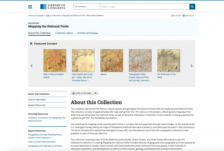
The Library of Congress offers this digital collection of 173 maps that either document U.S. national parks or document regions that would later be designated as national parks. More specifically, the collection documents depictions of four parks (Yellowstone, Acadia, the Grand Canyon, and the Great Smoky Mountains) and includes items dating from the seventeenth century through the present. This...
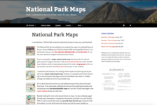
National Park Maps is an independently-run national park mapping website that provides an array of different types of maps and documentation for national parks and historic sites in the U.S. This site is especially handy for anyone who may be planning a trip to a national park and wants to explore by hiking (on designated trails or in the backcountry) and camping. Visitors to the site can explore...
The National Park Service Data and Information Web site contains several helpful links for data related to the Parks. The Data Clearinghouse link has national and regional data sets such as civil war and land status data, local and regional historic and scenic trails data sets, and information on the Virgin Islands in a well designed and easily browseable format. The Interactive Map Center allows...
Developed by the Wilderness Society, the Pick a Trail Web site offers general information about backpacking and hiking in the United States and different trails in other countries, such as the United Kingdom. The trails featured on the site are organized alphabetically, with a special emphasis placed on those trails leading through the US National Park System. Information on each trail includes a...