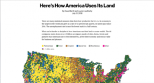
Map aficionados may enjoy this intriguing series of data visualizations published by Bloomberg in late July 2018. Here, readers will find an interactive visual explanation of land use in the continental United States based on different categorizations used by the U.S. Department of Agriculture (USDA). As viewers scroll through the colorful maps, which alternate between showing the approximate...
This interactive map from the US Department of Agriculture displays US land use areas by color. Clicking on a region of the map takes you to a page featuring a blown-up map and a paragraph describing the major land use of the area (e.g., agriculture, residential, industrial, etc.). From there, you can also access regional elevation, climate, water, and soil information.
Those interested in aerial photographs, satellite images, or maps as ways to conceptualize the world, will find this site interesting, entertaining, and educational. The US Dept. of Interior offers a National Atlas of the United States, an interactive resource that allows users to view part or all of the US and overlay layers of information including natural features, political boundaries, federal...
The US Geological Survey's Gap Analysis Program (GAP) is a cooperative project that attempts to map land cover and vertebrate species distribution in order to enhance conservation land management activities. Visitors can view data about protected areas and species as well as read USGS publications on this program.