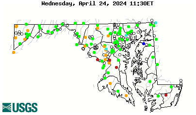
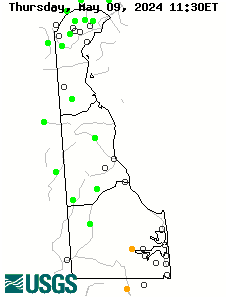
Real-Time
| Real Time MD Streamflow | Real Time DE Streamflow |
|---|---|
 |
 |

...read more in the current MD-DE-DC Monthly Water Conditions Summary
The real-time data used to produce this map are provisional and have not been reviewed or edited. They may be subject to significant change. The map depicts streamflow conditions as measured at USGS gaging stations. The colors represent discharge as a percentile, which is computed from the period of record for the current day of the year. Only stations having at least 30 years of record are used.
Active real-time stations having more than 30 years of continuous record are shown as colored circles. Uncolored circles depict stations having less than 30 years of record, or that are currently not transmitting.
Note: Hold down the Shift key and click on Reload or Refresh to make sure you have the most recent image or table.
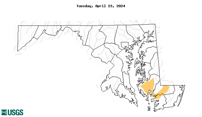
Drought Status
Maryland
Drought status according to Maryland Department of the Environment. For more information, visit: http://www.mde.state.md.us/programs/water/droughtInformation/pages/water/drought/index.aspx

Delaware
Department of Natural Resources and Environmental Control (DNREC)
District of Columbia
Metropolitan Washington Council of Governments (MWCOG):
Current Water Supply Report
Drought Stages
Drought Resources
Drought: Frequently Asked Questions
Drought Definitions
National Drought Monitoring
National Integrated Drought Information System (NIDIS)
National Climatic Data Center (NCDC)
US Drought Monitor
Weather and Climate
Northeast Regional Climate Center (NRCC)
NWS Sterling
NWS Philadelphia
Middle Atlantic River Forecast Center: MARFC Departures from Average
Maryland Weather Blog: The Baltimore Sun
Water Supply
Baltimore City
Delaware River Basin Commission (DRBC)
Interstate Commission on the Potomac River Basin
Susquehanna River Basin Commission (SRBC)
Washington Suburban Sanitary Commission (WSSC)
Water Conservation
Maryland Department of the Environment: Water Conservation
Water Wise Website
Use It Wisely