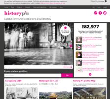
Historypin is "a global community collaborating around history," and they have successfully "pinned down" over 281 thousand items to various locations around the world. Over 1,400 institutions and 50 thousand visitors have participated thus far. It's a remarkable experiment in community mapping of everything from Hurricane Sandy to sharing memories of the Queen's visits to foreign lands. Visitors...
Compiled by Tony Campbell, Map Librarian at the British Library, this site is a gateway to the History of Cartography. Users will find information on a variety of map-related resources, including conferences, fellowships, current research guides, journals, lecture series, map collections, and map interest societies. Additional features include a list of related links and a brief introduction to...
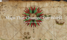
Cartography enthusiasts will want to delve into Maps That Changed Our World: an Esri Story Map created by Julie Stoner, Rodney Hardy, and Craig Bryant of the Library of Congress Geography and Map Division. This story map is a digital interactive project that highlights a handful of fascinating maps created over the past several centuries. Maps that Changed Our World starts by introducing visitors...
The National Library of Scotland has three collections of maps online: Maps of Scotland, 1560-1928; Pont's Map's of Scotland, ca. 1583 - 1596; and Military Maps of Scotland. Maps of Scotland contains 800 early maps -- including maps of the whole country, county maps, town plans, and sea charts -- while the Pont's Map's of Scotland contains 77 manuscript maps made by Timothy Pont. On the search...
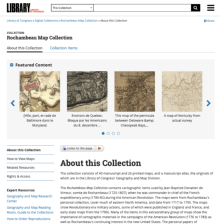
Military maps continue to fascinate the general public, and this collection from the American Memory Project at the Library of Congress will be of great interest to those with a penchant for American history and cartography. This particular collection contains maps collected and used by Jean Baptiste Donatien de Vimeur, comte de Rochambeau during the American Revolution. Rochambeau served as the...
This site is an addition to an existing Library of Congress (LOC) American Memory Project (last reviewed in the April 30, 1999 Scout Report) collection. The new resource, Abraham Ortelius's Theatrum Orbis Terrarum (Theater of the World), was published in 1570 and "considered the first true atlas in the modern sense." Located in the special atlases presentation section on the General Map...
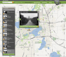
Have you ever walked by a busy street corner and wondered what was there 20, 30, 50, or 60 years ago? If you have, the WhatWasThere site may be able to provide you with answers. The premise of the site is simple: the team at WhatWasThere has provided a platform where anyone can upload a photograph with two tags (location and year) so that others can learn more about the built environment. Visitors...
Developed as part of President Franklin D. Roosevelt's massive package of assistance programs designed to pull the United States out of the Great Depression, the Works Progress Administration (WPA) was known for employing thousands of artists to paint murals in federal buildings and for also employing thousands of the nations' unemployed in hundreds of massive construction projects around the...