The Road to Agincourt
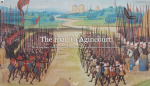
On October 25, 1415, the ill and exhausted English army (led by King Henry V, who had inherited the throne just two years earlier) was badly outnumbered by the French army, which was in much better condition. Given these disparities, an English defeat may have seemed inevitable - but in a remarkable turn of events, the English were victorious, and the Battle of Agincourt turned Henry V into a hero of the Hundred Years' War. Readers curious to learn more about this important battle may enjoy The Road to Agincourt, created on Esri's story maps platform. After setting the stage with background information about the events leading up to the conflicts of 1415, the story map takes readers on a narrative journey (illustrated by numerous maps, images, and graphics) that follows Henry V's invasion of France as well as France's resistance in the weeks preceding Agincourt before diving into the battle itself. Along the way, readers are treated to informative commentary full of details about the two armies' weaponry, strategies, and more. Published in 2018, this richly visual story map was crafted by Ioannis-Rafail Chatzis, a master's student at the University of Edinburgh. As of this write-up, this resource is best viewed in Firefox and may occasionally need a moment to load completely.
Archived Scout Publication URL
Scout Publication
Creator
Publisher
Classification
GEM Subject
Language
Date of Scout Publication
October 25th, 2019
Resource URL Clicks
254
Comments