Neighborhood Atlas
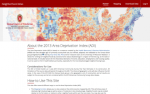
Policy makers, grant writers, and public health researchers may be interested in the Neighborhood Atlas, an interactive resource that allows visitors to review the Area Deprivation Index (ADI) of neighborhoods across the United States. The ADI is a numerical measure of public health that was developed by the Health Resources and Service Administration. More recently, a team headed by Amy Kind of the UW-Madison's Department of Medicine adapted the ADI to be used on the level of census blocks. The ADI "includes factors for the theoretical domains of income, education, employment, and housing quality," and, "can be used to inform health delivery and policy, especially for the most disadvantaged neighborhood groups." The Neighborhood Atlas (created by the Applied Population Lab at UW-Madison) allows visitors to view ADI data by census block by selecting a state of interest. The ADI figures for this map are based on the 2013 American Community Survey Five Year Estimates. Researchers may also download this data by creating a free login.
Archived Scout Publication URL
Scout Publication
Classification
GEM Subject
Language
Date of Scout Publication
July 20th, 2018
Resource URL Clicks
351
Comments